
Hydraulic models are mathematical models of a fluid flow system such as a water system, a sewer system, or a storm system, and it’s used to analyze systems hydraulic behavior. Hydraulic models illustrate the effects of changing demand and climactic conditions on water distribution and wastewater collection systems – predicting pressures and identifying bottlenecks – and demonstrate the effectiveness of proposed solutions. By testing different alternatives and using the existing system to full advantage, hydraulic models help utilities minimize the cost of improvements.
___________________________________________________________________________________________________________________________________
Physical Habitat Simulation (PHABSIM)
The purpose of the Physical Habitat Simulation System (PHABSIM) is to simulate a relationship between streamflow and physical habitat for various life stages of a species of fish or a recreational activity. The basic objective of physical habitat simulation is to obtain a representation of the physical stream so that the stream may be linked, through biological considerations, to the social, political, and economic world. The two basic components of PHABSIM are the hydraulic and habitat simulations of a stream reach using defined hydraulic parameters and habitat suitability criteria. Hydraulic simulation is used to describe the area of a stream having various combinations of depth, velocity, and channel index as a function of flow. This information is used to calculate a habitat measure called Weighted Usable Area for the steam segment from suitability information based on field sampling of the various species of interest.
Description: PHABSIM.pdf Website: https://www.usgs.gov/software/physical-habitat-simulation-phabsim-software-windows
___________________________________________________________________________________________________________________________________
MOdel for Urban SEwers (MOUSE)
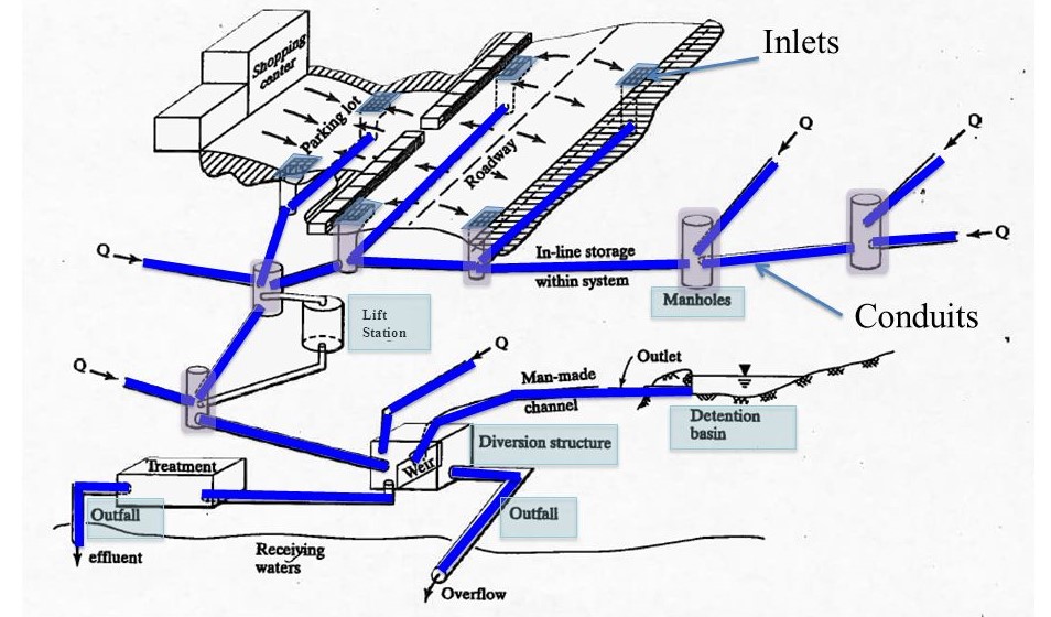
MOUSE is a comprehensive modeling system for analysis of urban drainage and sewer systems including links to GIS. MOUSE simulates spatial variations in flows, water levels, sediment transport and pollution in pipes and open drains. MOUSE can be used for the prediction of hydraulic deficiencies, overflow sites, flood inundation areas, effect of real-time control, etc. MOUSE engine is used in the MIKE-URBAN widely used in modelling city water networks , including water distribution systems, storm water drainage systems, and sewer collection in separate and combined systems
Description: MOUSE.pdf Website: http://www.dhigroup.com
___________________________________________________________________________________________________________________________________
Diffusion Analogy Flow Model (DAFLOW)
The model provides a time series of discharge, flow area, top width, and tributary inflow at node points along a system of one-dimensional open channels. The time series of hydraulic variables can be used as input hydraulics by a transport model, such as the BLTM water quality model. The model is designed to operate with a minimum of field data. It requires no cross sectional information, the channel properties being defined by hydraulic geometry coefficients which have been found to be fairly predictable for a wide range of river sizes throughout the world. The flow must be unidirectional and backwater must not be significant, so a downstream boundary condition is not required. Model accuracy improves with river slope and model time step size. The accuracy is excellent for upland streams and it can be used can be used with good accuracy for time steps as short as one hour as long as the slope is greater than 0.0003.
Description: DAFLOW.pdf. Contact: hejobson@verizon.net
___________________________________________________________________________________________________________________________________